Heybrook Lookout
The Heybrook Lookout sits atop its namesake ridge at 1,700 feet. The lookout itself rises 67 feet above the ridgeline and provides spectacular views of breathtaking glacial peaks surrounding the valley. The first Heybrook fire lookout was a simple tent platform built in 1925. The Forest Service replaced it seven years later with a 45-foot log leg tower, with a ground-level cabin intended as sleeping quarters for fire rangers; however, rampant rodents eventually drove the rangers up into the tower where they lived until a 67-foot lookout was built in 1964. Heybrook Lookout is one of only 106 lookouts left in Washington State.
Check availability on Recreation.gov ↗

Site mix
| Fire lookouts | 1 |
Site guide
1 site. Tap a filter to narrow the list; the map follows.
| Site | Shade | People / vehicles | Rating |
|---|---|---|---|
| Heybrook Lookout | Partial | 4 / 4 | Standard |
Per-site records as published by the managing agency on Recreation.gov. Blank cells mean the agency listed nothing for that site. Check-in 2:00 PM, checkout 1:00 PM.
Amenities & rules
| Max vehicle length | 25 ft |
| Fees | There is no pay and scan |
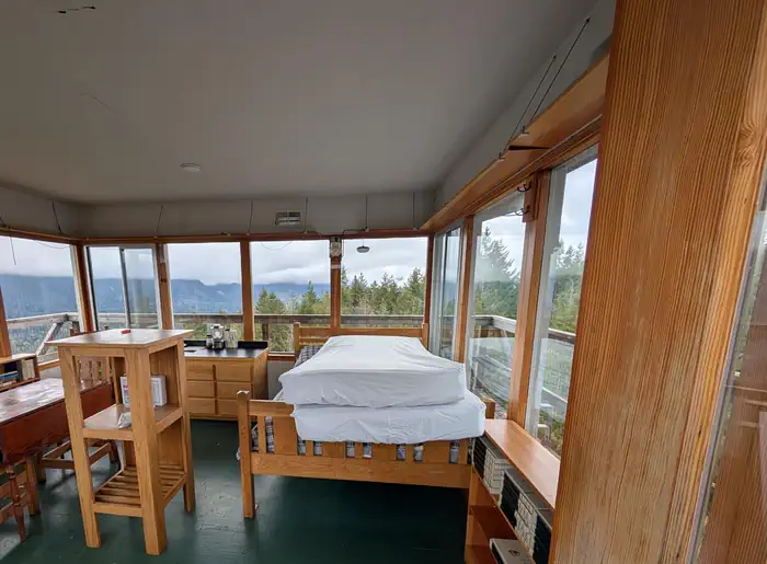
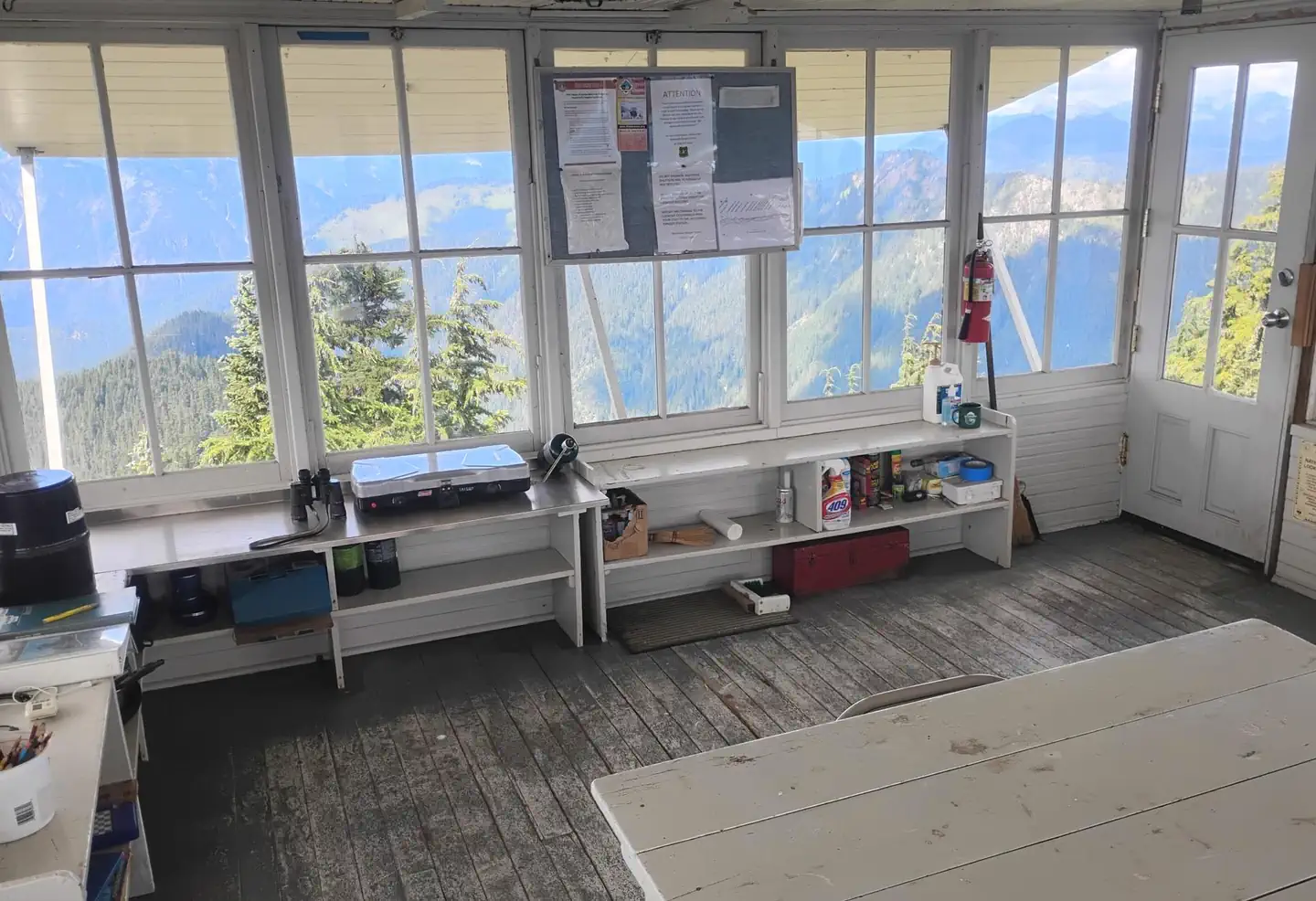
The 14 x14-ft. lookout cabin sleeps four and is furnished with one twin-sized bed with mattress, two additional floor mattresses, a table and chairs, propane stove, pot, pan, silverware, coffee pot and battery operated lanterns. A primitive vault toilet is located several hundred feet down the ridge from the lookout. There is a picnic table at the bottom of the tower. There is no water at the site. Guests must bring water for drinking, cooking and washing. Guests must also bring flashlights, sleeping bags, towels, dish soap, matches, a first aid kit, toilet paper and garbage bags. All trash and food must be packed out, and guests are expected to clean the cabin before leaving
Individual sites vary. Confirm on Recreation.gov or with the managing office.
Weather by month
Getting there
Drive U.S. 2 for 2 miles east of the town of Index, just past milepost 37. Limited parking for the trailhead is located on the north side of the highway across from the Mt. Baker-Snoqualmie National Forest sign. From the trailhead, it is a 1 mile hike to the lookout with an elevation gain of 900 feet.
| Nearest town | Skykomish, Washington |
| Coordinates | 47.8084° N, 121.5352° W · Directions ↗ |
Fire nearby
- WildfireKing
27 mi from the campground · 3,427 acres · 36% contained
- WildfireThree Queens
30 mi from the campground · 9,575 acres · 33% contained
- WildfireLittle Giant
35 mi from the campground · 172,912 acres · 95% contained
- WildfireSisi
49 mi from the campground · 4,615 acres · 34% contained
Distance is to the reported incident point, not the fire edge. Call the managing office before you drive.
Supplies & services
| Outdoor gear | Stevens Pass Snowboard Shop ↗ | 8.1 mi |
| RV sales & service | Open Road RV ↗ | 21.1 mi |
| Dump station | Dump station ↗ | 21.2 mi |
Locations © OpenStreetMap contributors. Call ahead; hours change seasonally.
Explore
Worth a stop
Deception Falls Picnic Area, Lake Serene/Bridal Veil Falls hikes, and the Iron Goat historic interpretive trail.
- 14.5 miNorth Fork Skykomish Trailhead ↗Trailhead
Trails nearby
- under 0.1 miHeybrook Lookout1 mi trail · hiking
- 1.7 miCable Drop0.3 mi trail · hiking
- 2 miBridal Veil Falls0.4 mi trail · hiking
- 2 miLake Serene3.1 mi trail · hiking
- 3.3 miBarclay Creek Road ↗6.2 mi trail · motorcycle, ATV, e-bike, snowmobile and 2 more
- 3.7 miBarclay Lake2.3 mi trail · hiking
Trailheads within three miles
- 1.8 miLake Serene Trailhead ↗Mt. Baker-Snoqualmie National Forest
Trail and trailhead records are the Forest Service's. Distances are straight-line to the nearer trail end. Trail conditions are not tracked here.
Public land it sits in
This campground sits inside Wild Sky Wilderness, which overlaps Mt. Baker-Snoqualmie National Forest.
- inWild Sky Wilderness ↗Wilderness · Forest Service · 105,543 acres
- inMt. Baker-Snoqualmie National Forest ↗National Forest · Forest Service · 2,025,595 acres
- inOkanogan-Wenatchee National Forest ↗National Forest · Forest Service · 3,858,129 acres
Each unit is published as a centre point and an acreage rather than a boundary, so this section stands it in for a circle of the same area. Whether a campground is inside, and how far it is from one it is outside, are both approximate.
Other campgrounds nearby

Cabin and lookout rentals nearby
On the National Register nearby
- Red Men HallBuilding · Index · 1.2 mi
- Bush HouseBuilding · Index · 1.3 mi
- Baring BridgeStructure · Baring · 3.9 mi
Natural features
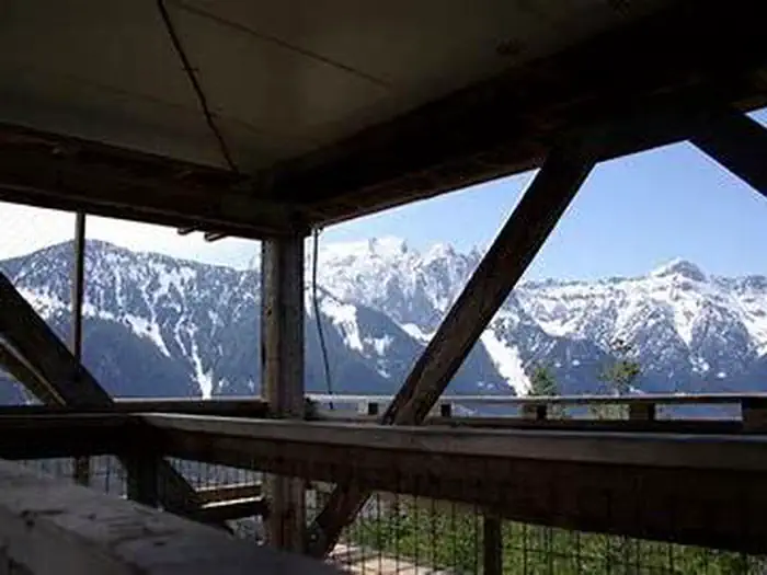
On a clear day, guests at Heybrook Lookout see views of Mount Index and Bridal Veil Falls, Mount Baring, Mount Persis and the Wild Sky Wilderness. Wildlife is abundant, and guests may catch a glimpse of black bears, bobcat, elk or bald eagle. Wolves are making a comeback to the area, but they are usually heard and not seen.
Recreation
Hiking, birding and wildlife viewing are popular activities around the lookout.
Guidebooks for Washington
We earn a small commission if you buy through these links. It does not change what we list.
Titles come from Open Library's catalog, matched by subject heading or by title.
Reference
Questions people ask
Do I need a reservation at Heybrook Lookout?
Sites at Heybrook Lookout are reservable on Recreation.gov. Any walk-up sites are listed on the booking page.
Source: Recreation.gov
How much does it cost to camp at Heybrook Lookout?
There is no pay and scan
Source: Recreation.gov
What time is check-in at Heybrook Lookout?
Check-in 2:00 PM, checkout 1:00 PM.
Source: Recreation.gov
How many sites does Heybrook Lookout have?
1 site, including 1 lookout.
Source: Recreation.gov
Will my RV fit at Heybrook Lookout?
The longest site here provides 25 feet of vehicle capacity. Most sites are shorter. The sidebar tool checks a trailer or motorhome length against every site.
Source: Will my RV fit
Is there cell service at Heybrook Lookout?
FCC coverage maps show AT&T 4G LTE at the campground point. Terrain changes that from one site to the next.
Source: FCC Broadband Map
What is the nearest town to Heybrook Lookout?
Skykomish, Washington. Deception Falls Picnic Area, Lake Serene/Bridal Veil Falls hikes, and the Iron Goat historic interpretive trail.
Source: Getting there
What if Heybrook Lookout is full?
The nearest public campgrounds are Money Creek Campground (8.1 mi), Troublesome Creek Campground (8.7 mi, partly first-come), and Miller River Group Camp (10.4 mi).
Source: Campgrounds nearby