Radium Recreation Area
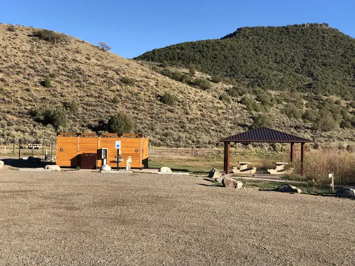
Managed By Kremmling Field Office The Radium Recreation Area is part of the Upper Colorado River Special Recreation Management Area (SRMA), providing opportunities for developed camping and river access. With over 100,000 annual visitors the sites facilities include 2 developed boat ramp sites, 9 vault toilets, day use and overnight parking, 16 single campsites and 2 Group Campsites and 3 day use shade structures. There is no potable water provided at this area. The area is used by visitors to access the river for float boating and fishing opportunities.
More like this: reservable in Colorado · tent only in Colorado · pets allowed in Colorado · group sites in Colorado
Check availability on Recreation.gov ↗

Site mix
| Standard, no hookups | 12 |
| Walk-in | 4 |
| group shelter nonelectric | 3 |
| Group sites | 2 |
Site guide
18 sites. Tap a filter to narrow the list; the map follows.
| Site | Type | Entry | Fits, ft | Surface | Shade | Water / sewer | People / vehicles | Fires | Accessible |
|---|---|---|---|---|---|---|---|---|---|
| 5 | Standard | Pull-through | 80 | Gravel | None | No / – | 10 / 2 | ||
| 6 | Standard | Pull-through | 80 | Gravel | None | No / – | 10 / 2 | ||
| 7 | Standard | Pull-through | 80 | Gravel | None | No / – | 10 / 2 | ||
| 8 | Standard | Pull-through | 80 | Gravel | None | No / – | 10 / 2 | ||
| 9 | Standard | Pull-through | 80 | Gravel | None | No / – | 10 / 2 | ||
| 10 | Standard | Pull-through | 80 | Gravel | None | No / – | 10 / 2 | ||
| 11 | Standard | Pull-through | 80 | Gravel | None | No / – | 10 / 2 | ||
| 12 | Standard | Pull-through | 80 | Gravel | None | No / – | 10 / 2 | ||
| 13 | Standard | Pull-through | 80 | None | No / – | 10 / 2 | |||
| 14 | Standard | Back-in | 30 | None | No / – | 10 / 2 |
Per-site records as published by the managing agency on Recreation.gov. Blank cells mean the agency listed nothing for that site. Check-in 1:00 PM, checkout 12:00 PM.
Amenities & rules
| Max vehicle length | 18 ft |
| Equipment | Tents |
| Pets | Allowed |
| Campfires | Allowed, subject to restrictions |
| Fees | Fees are required for day use and camping between April 1 - November 30. Campgrounds are closed with no service between December 1 - March 31. • Single Campsites - $25.00 per site - maximum of 10 people. • Group Campsites - $75.00 per site - maximum of 30 people. |
| Accessibility | Site 16 is listed accessible |
Campsites 1-4 are walk-in sites and have parking for one vehicle without a trailer. Campsites 5-13 have pull through parking areas and can typically fit one to two vehicles and small trailers. Campsites 14-16 have pull in parking and is 30 feet in length or less. Additional vehicles not fitting within a campsite's designated parking must park in the general parking areas. There are no electric hook-ups and cell service non-existent without a booster. There are two boat ramps with restrooms.
Individual sites vary. Confirm on Recreation.gov or with the managing office.
Weather by month
Getting there
| Nearest town | Bond, Colorado |
| Coordinates | 39.9514° N, 106.5560° W · Directions ↗ |
Good to know
- Parking is not permitted along the narrow Radium Road between the Radium Recreation Area and Trough Road to ensure safe passage of vehicles and ensure clear passage for Emergency Vehicles when needed.
- Each campsite must be reserved through Recreation.gov and has varying space for parking (see parking size limitations before completing your reservation), a picnic table, a fire ring, and close proxim
Fire nearby
- WildfireWillow
50 mi from the campground · 7,359 acres · 92% contained
Distance is to the reported incident point, not the fire edge. Call the managing office before you drive.
Supplies & services
| Dump station | Dump station ↗ | 21.2 mi |
| Outdoor gear | Marmot ↗ | 23.6 mi |
Locations © OpenStreetMap contributors. Call ahead; hours change seasonally.
Explore
Video
The Campground near Radium, CO. A guide to lesser known sites in the American West. S06E
Worth a stop
The town of Kremmling, CO is approximately 20 miles east from Radium Recreation Area where visitors can get supplies. Rancho Del Rio – a private resort along the Colorado river, has a small store with supplies and is a river access point for those recreating on the river. Rancho Del Rio is located approximately 6 miles west along Trough Road. Trough Road, which accesses the BLM Recreation Areas and Rancho Del Rio (private river access – fee site) is the Colorado Headwaters National Scenic and Historic Byway. Originating just east of Grand Lake on Highway 34, the byway ends at State Bridge.
- 12.2 mi
- 13.2 miKing Mountain Trailhead 131 ↗Trailhead
- 13.2 miStiffel Creek Trailhead ↗Trailhead
- 13.9 miBarger Gulch Fishing Access ↗Fishing site
Public land it sits in
This campground sits inside White River National Forest.
- inWhite River National Forest ↗National Forest · Forest Service · 2,482,711 acres
- 14.8 miEagles Nest Wilderness ↗Wilderness · Forest Service · 135,104 acres
Each unit is published as a centre point and an acreage rather than a boundary, so this section stands it in for a circle of the same area. Whether a campground is inside, and how far it is from one it is outside, are both approximate.
Other campgrounds nearby


Cabin and lookout rentals nearby
On the National Register nearby
- State BridgeStructure · State Bridge · 8.1 mi
- Rock Creek Stage StationBuilding · Toponas · 8.7 mi
- WaterwheelSite · McCoy · 9.2 mi
Natural features
The Radium Recreation Area is adjacent to the Colorado River next to the small town of Radium. The scenery within the area is a major component to the adjacent Colorado Headwaters National Scenic and Historic Byway and are important features that make this stretch of river Wild and Scenic Eligible.
Recreation
Recreation opportunities include river access for fishing and float boating. On-site picnic shelters provide visitors with opportunities to a covered area for relaxing and picnicking. Note – Radium Warm Springs Access: There are no designated trails from this area and there is no designated access to the Radium Warm Springs. Please respect the social trail closures and restoration conducted on BLM managed lands along Radium Road that protect area wildlife habitat including area Big Horn Sheep. The Colorado Parks and Wildlife Mugrage Site along Radium Road, including the restroom and social trail that accessed the Radium Warm Springs within the Radium State Wildlife Area, is closed for the protection of this important habitat.
Guidebooks for Colorado
We earn a small commission if you buy through these links. It does not change what we list.



Titles come from Open Library's catalog, matched by subject heading or by title.
Reference
Questions people ask
Do I need a reservation at Radium Recreation Area?
Sites at Radium Recreation Area are reservable on Recreation.gov. Any walk-up sites are listed on the booking page.
Source: Recreation.gov
How much does it cost to camp at Radium Recreation Area?
Fees are required for day use and camping between April 1 - November 30. Campgrounds are closed with no service between December 1 - March 31. • Single Campsites - $25.00 per site - maximum of 10 people.
Source: Recreation.gov
What time is check-in at Radium Recreation Area?
Check-in 1:00 PM, checkout 12:00 PM.
Source: Recreation.gov
How many sites does Radium Recreation Area have?
21 sites, including 12 standard sites without power, 4 walk-in sites, 3 group shelter nonelectric, and 2 group sites.
Source: Recreation.gov
Will my RV fit at Radium Recreation Area?
The longest site here provides 18 feet of vehicle capacity. Most sites are shorter. The sidebar tool checks a trailer or motorhome length against every site.
Source: Will my RV fit
Are pets allowed at Radium Recreation Area?
Yes, pets are allowed at Radium Recreation Area. Leash rules apply.
Source: Recreation.gov
Can I have a campfire at Radium Recreation Area?
Fires are allowed in the provided rings under normal conditions. As of 2026-10-16, there is 1 active fire within 50 miles, so check current restrictions before you light one.
Source: Fire nearby
Are there accessible sites at Radium Recreation Area?
Site 16 is listed accessible on Recreation.gov. What that covers (a paved pad, an accessible table, a nearby accessible restroom) is on each site's booking page.
Source: Recreation.gov
What is there to do at Radium Recreation Area?
Recreation opportunities include river access for fishing and float boating. The Recreation section on this page has the rest.
Source: Recreation
What is the nearest town to Radium Recreation Area?
Bond, Colorado. The town of Kremmling, CO is approximately 20 miles east from Radium Recreation Area where visitors can get supplies.
Source: Getting there
What if Radium Recreation Area is full?
The nearest public campgrounds are Pumphouse Recreation Area (3.5 mi), Blacktail Creek Campground (8.1 mi, first-come), and Lynx Pass Campground (12.6 mi, first-come).
Source: Campgrounds nearby