Liz Creek Cabin
Liz Creek Cabin was built in 1929 in the remote backcountry as a Forest Service guard station and is eligible for the National Register of Historic Places. An extensive restoration that was completed in 2014 brought the cabin back to life as a rental available to the public. The small single room cabin has a loft and a covered porch. Although there are several entry points to the area, the site is only accessible by the single track multi use portion of Weitas Creek trail #20 that connects 12-mile saddle to the North Fork of the Clearwater River.
Check availability on Recreation.gov ↗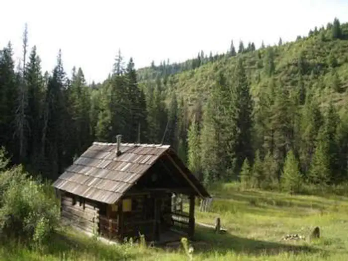
Site mix
| Cabins | 1 |
Site guide
1 site. Tap a filter to narrow the list; the map follows.
| Site | People / vehicles |
|---|---|
| Liz Creek Cabin | 4 / – |
Per-site records as published by the managing agency on Recreation.gov. Blank cells mean the agency listed nothing for that site. Check-in 10:00 AM, checkout 10:00 AM.
Amenities & rules
The small primitive cabin has a loft and a covered porch and can accommodate a maximum of four people. There are sleeping cots, table with chairs, wood heating stove, storage cabinet, and a fire ring outside. The remote site offers no modern amenities, an outhouse with pit toilet is located a short distance from the cabin, and a stream provides water that needs to be treated before consuming. Guests must bring their own supplies and gear for a comfortable stay as there are no linens or toiletries provided. Guests are required to pick up after their pets/stock, take their trash and clean the cabin before they check-out with the provided cleaning supplies,under the “Leave it Cleaner than when you arrived” and the “Pack it in Pack it out” policies so everyone may enjoy their stay.
Individual sites vary. Confirm on Recreation.gov or with the managing office.
Weather by month
Getting there
Liz Creek Cabin located in the very remote portion of the upper Weitas Creek drainage on the North Fork Ranger District of the Nez Perce-Clearwater National Forest in Idaho, approximately 25 air miles due east of Pierce Idaho.
| Nearest town | Orofino, Idaho |
| Coordinates | 46.4803° N, 115.2894° W · Directions ↗ |
Good to know
- Visitors are strongly advised to consult the forest website, as well as a map prior to reserving or traveling to the cabin and to call the district information desk for any questions.
Fire nearby
- PrescribedRx Rescue Jensen Nfrd
16 mi from the campground · 44 acres
- WildfireMoose Mountain
21 mi from the campground · 5,832 acres · 90% contained
- PrescribedRx Barnyard Units Nfrd
25 mi from the campground · 41 acres
- PrescribedRx Stray Creek Lcrd
29 mi from the campground · 150 acres
Distance is to the reported incident point, not the fire edge. Call the managing office before you drive.
Supplies & services
| RV sales & service | Hamilton RV Sales Of Montana ↗ | 55.9 mi |
Locations © OpenStreetMap contributors. Call ahead; hours change seasonally.
Explore
Worth a stop
Depending on how you decide to travel into the cabin, there are many attractions along the way including the historic Lolo Motorway that stretches 100 miles through scenic mountain landscapes with spectacular views as it parallels a portion of the Lewis and Clark and the Nez Perce trails. Sites include but not limited to places such as; The Smoking Place, The Sinque Hole, and Spirit Revival Ridge. The North Fork ranger district prides itself on the diversity of world class recreational opportunities ranging from bird/wildlife watching, big game hunting, whitewater rafting, leisurely floats, secluded backpacking/equestrian trails into the high mountain backcountry, to motorized OHV/ ATV/UTV trail systems. These unique opportunities draw visitors from around the world and of all walks of life. Summer visitors also have the opportunity to observe meadows and hillsides blanketed in colorful wildflowers throughout much of the season. Travelers should be prepared for rough sometimes treacherous conditions. No services are located along this road so travelers should have plenty of gas, food, and water for the drive.
- 8.6 miEagle Mountain Trailhead ↗Trailhead
- 13.1 miMocus Point Trailhead ↗Trailhead
Trails nearby
- 0.1 miLiz Butte4 mi trail
- 0.4 miBald Ridge3.7 mi trail
- 0.7 miPorphyry Peak ↗6 mi trail
- 1.5 miYokum Creek2.1 mi trail
- 1.6 miYokum Ridge2.4 mi trail
- 1.9 miSmith Butte ↗8 mi trail
Trail and trailhead records are the Forest Service's. Distances are straight-line to the nearer trail end. Trail conditions are not tracked here.
Public land it sits in
This campground sits inside Nez Perce-Clearwater National Forest.
- inNez Perce-Clearwater National Forest ↗National Forest · Forest Service · 4,072,795 acres
- 10.3 miSelway-Bitterroot Wilderness ↗Wilderness · Forest Service · 1,347,644 acres
Each unit is published as a centre point and an acreage rather than a boundary, so this section stands it in for a circle of the same area. Whether a campground is inside, and how far it is from one it is outside, are both approximate.
Other campgrounds nearby

Cabin and lookout rentals nearby
Natural features
Situated at an elevation of 3,500 feet at the confluence of Liz and Weitas Creeks, the site offers a panoramic view of the diverse surroundings. The forest beyond the cabin’s meadow varies from old growth conifer trees mixed with huge cedar snags from the great 1910 fires, to steep mountain sides filled with an abundance of vegetation, including Huckleberry, Mountain Maple, Thimble berry and alder. Weitas, and to a lesser extent Liz Creek, have multiple beaver dams unique to the area providing a water abundant habitat full of native flora/fauna, so visitors are likely to have several opportunities to catch a glimpse of the many species in the area. The cabin is an ideal base camp for those looking to reconnect with nature, or as a stopover for a variety of outdoor enthusiasts as they explore the district.
Recreation
While remote, this site offers a great chance to explore both riparian habitat and mountain vistas. Along with trail 20 a multi-use motorized trail, that is also open to ATV/UTV 50" or less from 12 Mile Saddle to within approximately 1.5 miles of the cabin. There are several other trails in the vicinity that offer connection to a host of recreation opportunities to the avid outdoors adventurer with berry picking, hiking, biking, sightseeing, fishing and hunting being the most popular.
Guidebooks for Idaho
We earn a small commission if you buy through these links. It does not change what we list.

Titles come from Open Library's catalog, matched by subject heading or by title.
Reference
Questions people ask
Do I need a reservation at Liz Creek Cabin?
Sites at Liz Creek Cabin are reservable on Recreation.gov. Any walk-up sites are listed on the booking page.
Source: Recreation.gov
What time is check-in at Liz Creek Cabin?
Check-in 10:00 AM, checkout 10:00 AM.
Source: Recreation.gov
How many sites does Liz Creek Cabin have?
1 site, including 1 cabin.
Source: Recreation.gov
What is there to do at Liz Creek Cabin?
While remote, this site offers a great chance to explore both riparian habitat and mountain vistas. The Recreation section on this page has the rest.
Source: Recreation
What is the nearest town to Liz Creek Cabin?
Orofino, Idaho. Depending on how you decide to travel into the cabin, there are many attractions along the way including the historic Lolo Motorway that stretches 100 miles through scenic mountain landscapes with spectacular views as it parallels a portion of the Lewis and Clark and the Nez Perce tr
Source: Getting there
What if Liz Creek Cabin is full?
The nearest public campgrounds are Wilderness Gateway (9.7 mi, partly first-come), Weitas Creek Campground (12.8 mi, first-come), and Noe Creek Campground (14.6 mi, first-come).
Source: Campgrounds nearby