Arid Peak Lookout
Arid Peak Lookout was built in 1934 to help detect fires that may have been sparked by the Milwaukee Railroad Line. It was last staffed in 1969 and sat idle for over 25 years before being renovated by a team of over 30 volunteers, the Forest Fire Lookout Association and the U.S. Forest Service. Arid Peak Lookout was restored to its original splendor in 1997 and is available for rent to the public. The lookout is listed on the National Register of Historic Lookouts and provides epic 360 degree views of the Bitterroot Mountains. Access to the cabin requires a moderately-steep 3 mile hike and availability is dependent on weather conditions.
Check availability on Recreation.gov ↗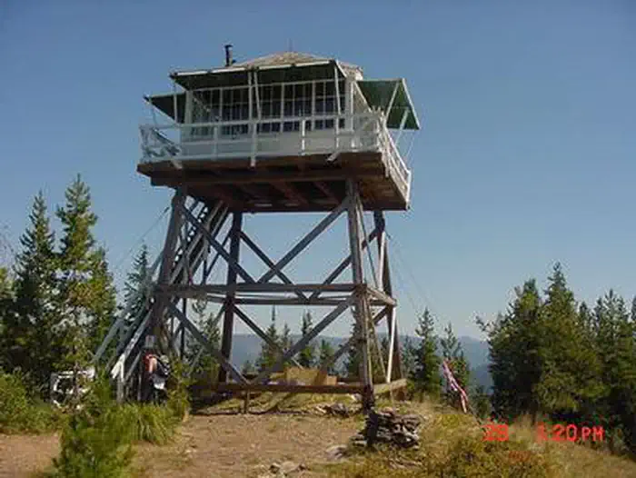
Site mix
| Cabins | 1 |
Site guide
1 site. Tap a filter to narrow the list; the map follows.
| Site | People / vehicles |
|---|---|
| 001 | 4 / – |
Per-site records as published by the managing agency on Recreation.gov. Blank cells mean the agency listed nothing for that site. Check-in 2:00 PM, checkout 11:00 AM.
Amenities & rules
The cabin fits up to four guests. Furnishings include two cots with mattresses, basic cooking gear, dishes, a propane lantern, propane camp stove, water containers, a table with two chairs and a wood stove. An outhouse is located outside the tower. No water is available so guests must bring their own or boil and treat stream water. Propane canisters are not included; a stock of 16.4 ounce canisters are required to use cooking and lighting equipment. Other items to pack include bedding, food, binoculars, a first aid kit, flashlights, towels, toilet paper, and dish soap.
Individual sites vary. Confirm on Recreation.gov or with the managing office.
Weather by month
Getting there
From Avery, turn left and head north up the North Fork of the St. Joe River Road #456 toward Wallace. Travel about 4.5 miles, then turn left down the hill just before the bridge across the river. You will then be on Road #1997, which is a single lane gravel road with pull outs.
| Nearest town | Avery, Idaho |
| Coordinates | 47.3589° N, 115.7653° W · Directions ↗ |
Fire nearby
- PrescribedD4 Rx Hwy 50 Roadside Salvage
11 mi from the campground
- WildfireNugget Hill
14 mi from the campground · 35 acres
- PrescribedD4 Rx Simmons Peak
30 mi from the campground
- PrescribedRx D7 Lost Creek 155/559
36 mi from the campground · 17 acres
Distance is to the reported incident point, not the fire edge. Call the managing office before you drive.
Supplies & services
| Dump station | Dump station ↗ | 7.5 mi |
| RV sales & service | Bobby Combs RV Centers ↗ | 53.8 mi |
Locations © OpenStreetMap contributors. Call ahead; hours change seasonally.
Explore
Trails nearby
- 0.1 miArid Peak ↗4.5 mi trail · hiking, horse, bike, motorcycle and 1 more
- 1.2 miKyle Creek3.9 mi trail · hiking, horse, bike, motorcycle
- 1.3 miWonderful Peak ↗4.6 mi trail · hiking, horse, bike, motorcycle and 1 more
- 1.3 miMozier Peak ↗4.7 mi trail · hiking, horse, bike, motorcycle
- 1.4 miLucky Swede ↗5.7 mi trail · hiking, horse, bike, motorcycle and 2 more
- 1.4 miHiawatha Rail Trail ↗14.6 mi trail · hiking, bike
Trail and trailhead records are the Forest Service's. Distances are straight-line to the nearer trail end. Trail conditions are not tracked here.
Public land it sits in
Idaho Panhandle National Forests begins about 6.5 miles away, and it is the closest of these.
- 6.5 miIdaho Panhandle National Forests ↗National Forest · Forest Service · 2,943,333 acres
Each unit is published as a centre point and an acreage rather than a boundary, so this section stands it in for a circle of the same area. Whether a campground is inside, and how far it is from one it is outside, are both approximate.
Other campgrounds nearby


Cabin and lookout rentals nearby
On the National Register nearby
- Bullion TunnelStructure · Avery · 4.2 mi
- Grand ForksSite · Avery · 4.4 mi
- Avery Ranger StationHistoric district · Avery · 7.7 mi
Natural features
The Arid Peak Lookout is located within the St. Joe River area of the Idaho Panhandle National Forests, an area that includes most of what was originally established as the St. Joe National Forest. The area is known for its blue-ribbon cutthroat trout streams, Wild and Scenic Rivers and extensive roadless and primitive areas. The St. Joe Rover area is also nationally recognized for its elk herds. The 20 foot tower sits at an elevation of 5,306 feet and overlooks the beautiful Loop Creek area and the scenic Hiawatha Bicycle Trail. The mixed conifer forest around the facility includes Douglas fir and spruce. Wildlife sightings of elk, deer, black bears, moose and bald eagles are common. This is bear country; Visitors are advised to be aware of and practice bear safety.
Recreation
The Hiawatha Bicycle Trail is considered the "crown jewel" of rail-to-trail mountain biking trails as it zips across seven trestles and through 10 tunnels in the magnificent Bitterroot Mountains. The trail can be accessed just over 10 miles from the lookout. The lookout offers access to the Arid Peak Trail #173, Mozier Peak Trail #174, and Kyle Creek Trail #175. All three trails are great for day-hiking, but can also be explored over longer backpacking treks or on horseback.
Nearby
The town of Avery has the nearest conveniences.
Guidebooks for Idaho
We earn a small commission if you buy through these links. It does not change what we list.

Titles come from Open Library's catalog, matched by subject heading or by title.
Reference
Questions people ask
Do I need a reservation at Arid Peak Lookout?
Sites at Arid Peak Lookout are reservable on Recreation.gov. Any walk-up sites are listed on the booking page.
Source: Recreation.gov
What time is check-in at Arid Peak Lookout?
Check-in 2:00 PM, checkout 11:00 AM.
Source: Recreation.gov
How many sites does Arid Peak Lookout have?
1 site, including 1 cabin.
Source: Recreation.gov
What is there to do at Arid Peak Lookout?
The Hiawatha Bicycle Trail is considered the "crown jewel" of rail-to-trail mountain biking trails as it zips across seven trestles and through 10 tunnels in the magnificent Bitterroot Mountains. The Recreation section on this page has the rest.
Source: Recreation
What is the nearest town to Arid Peak Lookout?
Avery, Idaho. The town of Avery has the nearest conveniences.
Source: Getting there
What if Arid Peak Lookout is full?
The nearest public campgrounds are Telichpah Campground (4.4 mi, first-come), Turner Flat Campground (9.9 mi, first-come), and Tin Can Flat Campground (11.2 mi, first-come).
Source: Campgrounds nearby