Lunch Peak Lookout
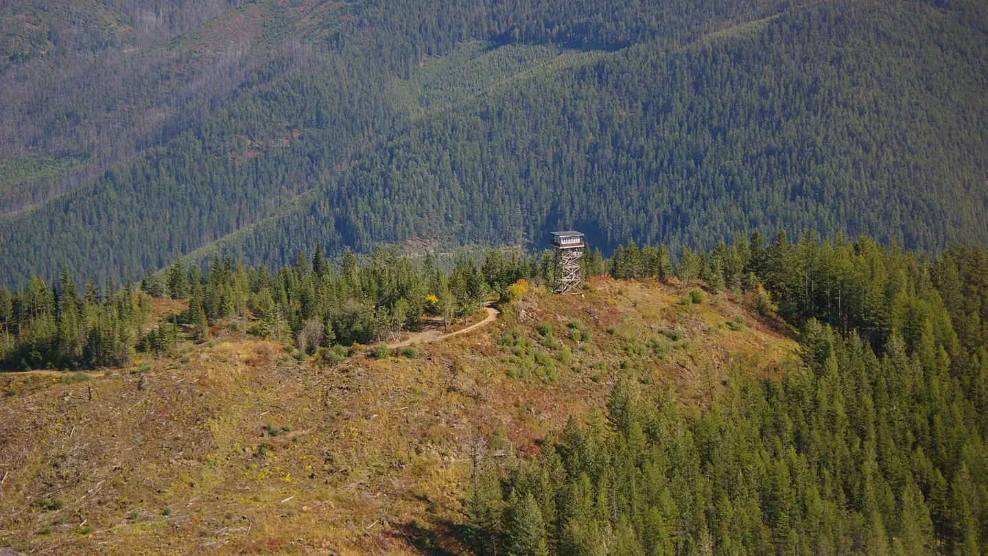
Lunch Peak lookout offers breathtaking views of Cabinet Mountain Wilderness, the Selkirk Mountains and Lake Pend Oreille. Located in the Cabinet Mountains, 35 miles northeast of Sandpoint, Idaho, the lookout sits at 6,414 ft. Guests can enjoy easy access to Pend Oreille Divide Trail #67. The lookout is remote and rustic with no heat, furnishings, water or cooking facilities. This basic structure lets visitors experience the feeling of "roughing it" while enjoying the cozy shelter and incredible views of the mountains and valleys below.
Check availability on Recreation.gov ↗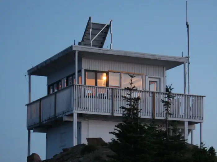
Site mix
| Cabins | 1 |
Site guide
1 site. Tap a filter to narrow the list; the map follows.
| Site | Surface | Shade | People / vehicles |
|---|---|---|---|
| 001 | Gravel | Partial | 4 / 2 |
Per-site records as published by the managing agency on Recreation.gov. Blank cells mean the agency listed nothing for that site. Check-in 3:00 PM, checkout 11:00 AM.
Amenities & rules
| Pets | Allowed |
The 15'x15' cabin was remodeled in 2002 and sits atop a 15' high cinder block foundation. No water or heat is provided. The lookout has limited furnishings which include a sleeping platform, table and cabinet. A modern vault toilet is located at the Pend Oreille Divide trailhead, 300 feet away. The last four miles of the access road is rough in spots and high clearance vehicles are necessary.
Individual sites vary. Confirm on Recreation.gov or with the managing office.
Weather by month
Getting there
From Sandpoint take Hwy 200 east 12 miles to Trestle Creek Road; turn left onto Trestle Creek Road #275 and go 12 miles to Lunch Peak Road #1091; turn left onto Road 1091 and go 4 miles to the lookout.
| Nearest town | Sandpoint, Idaho |
| Coordinates | 48.3681° N, 116.1850° W · Directions ↗ |
Fire nearby
- WildfireSilver
28 mi from the campground · 2,593 acres · 30% contained
- WildfireParker Lake
40 mi from the campground · 1,531 acres · 1% contained
- WildfireUpper Smith
43 mi from the campground · 4,848 acres · 41% contained
Distance is to the reported incident point, not the fire edge. Call the managing office before you drive.
Supplies & services
| Outdoor gear | North 40 ↗ | 17 mi |
| RV sales & service | Everything RV ↗ | 29.2 mi |
| Dump station | Dump station ↗ | 33.5 mi |
Locations © OpenStreetMap contributors. Call ahead; hours change seasonally.
Explore
Trails nearby
- 0.6 miChar Falls0.1 mi trail · hiking, horse, bike
- 0.7 miPend Oreille Divide ↗13 mi trail · hiking, horse, bike
- 1.6 miLake Darling ↗4.5 mi trail · hiking, horse, bike, snowmobile
- 1.7 miGem Lake1.4 mi trail · hiking, horse, bike
- 1.8 miGordon Creek1.9 mi trail · hiking, horse, bike
- 1.9 miTrestle Ridge ↗5.4 mi trail · hiking, horse, bike
Trail and trailhead records are the Forest Service's. Distances are straight-line to the nearer trail end. Trail conditions are not tracked here.
Public land it sits in
This campground sits inside Kootenai National Forest, which overlaps Idaho Panhandle National Forests.
- inKootenai National Forest ↗National Forest · Forest Service · 2,622,202 acres
- inIdaho Panhandle National Forests ↗National Forest · Forest Service · 2,943,333 acres
Each unit is published as a centre point and an acreage rather than a boundary, so this section stands it in for a circle of the same area. Whether a campground is inside, and how far it is from one it is outside, are both approximate.
Other campgrounds nearby

Cabin and lookout rentals nearby
Natural features
The lookout is located northeast of Sandpoint, Idaho and Lake Pend Oreille at an elevation of 6,414 feet. Bear, deer, elk, and cougar are among the wildlife native to the area. Visitors are cautioned to be aware of and practice bear safety while staying at Lunch Peak Lookout.
Recreation
The Pend Oreille Divide Trail #67 starts just below the lookout and is suitable for hiking, horseback riding and mountain biking. It follows ridge lines for much of its length and offers great views in all directions. A nice day hike is out to Mt. Pend Oreille and back. 8 miles roundtrip.
Nearby
The closest convenience store and fuel is located in Hope, Idaho, approximately 20 miles or a one hour drive.
Guidebooks for Idaho
We earn a small commission if you buy through these links. It does not change what we list.

Titles come from Open Library's catalog, matched by subject heading or by title.
Reference
Questions people ask
Do I need a reservation at Lunch Peak Lookout?
Sites at Lunch Peak Lookout are reservable on Recreation.gov. Any walk-up sites are listed on the booking page.
Source: Recreation.gov
What time is check-in at Lunch Peak Lookout?
Check-in 3:00 PM, checkout 11:00 AM.
Source: Recreation.gov
How many sites does Lunch Peak Lookout have?
1 site, including 1 cabin.
Source: Recreation.gov
Are pets allowed at Lunch Peak Lookout?
Yes, pets are allowed at Lunch Peak Lookout. Leash rules apply.
Source: Recreation.gov
What is there to do at Lunch Peak Lookout?
The Pend Oreille Divide Trail #67 starts just below the lookout and is suitable for hiking, horseback riding and mountain biking. The Recreation section on this page has the rest.
Source: Recreation
What is the nearest town to Lunch Peak Lookout?
Sandpoint, Idaho. The closest convenience store and fuel is located in Hope, Idaho, approximately 20 miles or a one hour drive.
Source: Getting there
What if Lunch Peak Lookout is full?
The nearest public campgrounds are Sam Owen (11.4 mi), Spar Lake Campground (12.6 mi, first-come), and Yaak River Campground (16.4 mi).
Source: Campgrounds nearby