Rock Bluff Group Site
Rock Bluff Group Site is just a short distance from Parker Canyon Lake in a remote and scenic region of the Coronado National Forest in southeastern Arizona. The site is open to groups of up to 50 people to enjoy camping and picnicking, as well as fishing and boating at the lake.
More like this: reservable in Arizona · pets allowed in Arizona · group sites in Arizona
Check availability on Recreation.gov ↗

Site mix
| group standard area nonelectric | 1 |
Site guide
1 site. Tap a filter to narrow the list; the map follows.
| Site | Shade | People / vehicles | Fires | Rating |
|---|---|---|---|---|
| 1 | Partial | 50 / 15 | Yes | Basic |
Per-site records as published by the managing agency on Recreation.gov. Blank cells mean the agency listed nothing for that site. Check-in 3:00 PM, checkout 12:00 PM.
Amenities & rules
| Pets | Allowed |
| Campfires | Allowed, subject to restrictions |
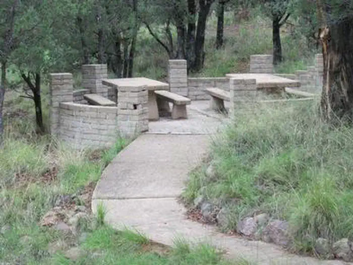
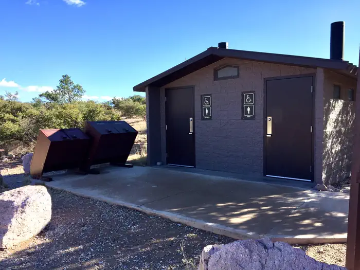
The camping area consists of three sites with two tables and two campfire rings each. Tables and grills are clustered on small, walled patios. The facility provides trash collection and toilets.
Individual sites vary. Confirm on Recreation.gov or with the managing office.
Season & status
| Status | Open |
| Season | Year-round |
| Forest | Coronado National Forest |
| Fees | Group site: $50 plus $10 per vehicle. |
| Rules | No cell service. No utility hookups. Firewood is not available at this site; please bring your own firewood or charcoal. Tree-cutting is prohibited. |
Weather by month
Getting there
From Tucson, drive east on I-10 to the Arizona Route 83 exit. Drive south to Sonoita, and then continue on 83 for approximately 25 miles to Parker Canyon Lake. From Sierra Vista, travel through Fort Huachuca's west gate to State Route 83. Turn south and travel 10 miles to Parker Canyon Lake.
| Nearest town | Hereford, Arizona |
| Coordinates | 31.4339° N, 110.4528° W · Directions ↗ |
Supplies & services
| Dump station | Dump station ↗ | 24.1 mi |
| RV sales & service | RV sales & service ↗ | 57.2 mi |
Locations © OpenStreetMap contributors. Call ahead; hours change seasonally.
Explore
Trails nearby
- 0.7 miLakeshore Trail #128 ↗5 mi trail · hiking, horse, bike
- 1.2 miArizona Trail Canelo Hills ↗30.2 mi trail · hiking, horse, bike · national_scenic_or_historic
- 1.2 miScotia Canyon ↗4.6 mi trail · hiking, horse, bike · national_scenic_or_historic
- 2.9 miHuachuca2.8 mi trail · hiking, horse, bike
- 3.1 miLyle Canyon2.9 mi trail · hiking, horse, bike
- 3.4 miEureka Mine1.6 mi trail · hiking, horse
Trail and trailhead records are the Forest Service's. Distances are straight-line to the nearer trail end. Trail conditions are not tracked here.
Public land it sits in
Miller Peak Wilderness begins about 4.3 miles away, and it is the closest of these.
- 4.3 miMiller Peak Wilderness ↗Wilderness · Forest Service · 20,251 acres
Each unit is published as a centre point and an acreage rather than a boundary, so this section stands it in for a circle of the same area. Whether a campground is inside, and how far it is from one it is outside, are both approximate.
Other campgrounds nearby


Cabin and lookout rentals nearby
On the National Register nearby
- Canelo SchoolBuilding · Canelo · 8.2 mi
- Little Outfit Schoolhouse, TheBuilding · Patagonia · 8.4 mi
- Canelo Ranger StationBuilding · Canelo · 9 mi
Natural features
The group camping area sits at an elevation of 5,400 feet in a small, rocky canyon dotted with oaks and junipers. Animals unique to the southwest, such as coatimundi, javelina and roadrunners, occasionally make appearances around the lake. The Coronado National Forest covers 1.78 million acres of southeastern Arizona and southwestern New Mexico. Elevations range from 3,000 to 10,720 feet in 12 widely scattered mountain ranges, or "sky islands," that rise dramatically from the desert floor, supporting biologically diverse plant communities.
Recreation
Campers can enjoy an interpretive trail around the lake that begins a quarter-mile walk from Rock Bluff. Trailside benches are located at some of the best wildlife viewing areas. Bald eagles are regularly sighted during the winter, and osprey are sometimes seen migrating through the area in the fall. For those who like to fish, Parker Canyon Lake offers both cold and warm water species, including stocked rainbow trout and resident bass, sunfish and catfish. Boating is available with a limit of one 10-horsepower motor or less. Day use fee $8/day or $10/week
Nearby
A lakeside developed recreation site, including a boat ramp, fishing pier, general store and boat rentals, is located just a short drive from the group area. Passes must be clearly displayed when in Day Use Areas.
Guidebooks for Arizona
We earn a small commission if you buy through these links. It does not change what we list.
- Best Backpacking Trips in Utah, Arizona, and New MexicoMike White and Douglas Lorain, 2016Find at Bookshop.org
Titles come from Open Library's catalog, matched by subject heading or by title.
Reference
Questions people ask
Do I need a reservation at Rock Bluff Group Site?
Sites at Rock Bluff Group Site are reservable on Recreation.gov. Any walk-up sites are listed on the booking page.
Source: Recreation.gov
How much does it cost to camp at Rock Bluff Group Site?
Group site: $50 plus $10 per vehicle.
Source: Recreation.gov
What time is check-in at Rock Bluff Group Site?
Check-in 3:00 PM, checkout 12:00 PM.
Source: Recreation.gov
Is Rock Bluff Group Site open right now?
Open as of Oct 16, 2026. Season Year-round.
Source: Forest Service status
How many sites does Rock Bluff Group Site have?
1 site, including 1 group standard area nonelectric.
Source: Recreation.gov
Are pets allowed at Rock Bluff Group Site?
Yes, pets are allowed at Rock Bluff Group Site. Leash rules apply.
Source: Recreation.gov
Can I have a campfire at Rock Bluff Group Site?
Fires are allowed in the provided rings under normal conditions. No cell service.
Source: Recreation.gov
What is there to do at Rock Bluff Group Site?
Campers can enjoy an interpretive trail around the lake that begins a quarter-mile walk from Rock Bluff. The Recreation section on this page has the rest.
Source: Recreation
What is the nearest town to Rock Bluff Group Site?
Hereford, Arizona. A lakeside developed recreation site, including a boat ramp, fishing pier, general store and boat rentals, is located just a short drive from the group area.
Source: Getting there
What if Rock Bluff Group Site is full?
The nearest public campgrounds are Lakeview Campground (0.4 mi, first-come), Ramsey Vista Campground (8.8 mi, first-come), and Reef Townsite Group Area (9.6 mi).
Source: Campgrounds nearby